 Oh My! Is it time to get out of Dodge?
 It's becoming quite obvious that this Labor Day weekend will see a storm, perhaps a major hurricane, making landfall someplace on the Gulf coast. Will it be Katrina all over again charging into New Orleans? We'll just have to wait for a few more days to be sure. All indications are that a storm of some magnitude will hit someplace between Texas and the Florida panhandle. Just look at the latest forecasts. It's time to get prepared - today, not Saturday or Sunday.
So, what can we do to learn where this storm may go and how strong it will be when it

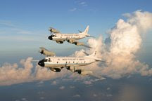
there? NOAA will be starting its flight program tomorrow with two flights, one on the high-altitude G-IV to map the steering currents that should provide us a better idea of where the storm may go. One of our P-3s will be going out into the Gulf with 60 ocean probes that will yield information on the heat available to intensify the storm. We all know that hurricanes get its energy from the ocean, and where you find warm pools of water in the

ocean, you will likely see intensification of the storm. By the end of the day tomorrow, data should be available that will help us with both our track and intensity forecasts. The tracks for these two missions are displayed here.
I will have the pleasure of joining the G-IV as it makes its way first out over the bahamas, then around Cuba and the storm and finally back to our home base at MacDill AFB in Tampa. At each of the numbered dots along the flight track we will be launching dropsondes from 45,000 ft., and as they fall to the surface they will radio back to the aircraft temperature, pressure, humidity and wind speed and direction twice each second. These data will be processed onboard, and then the operator will generate a message with the key data which will then be transmitted via our satellite communication link back to the National Weather Service. These data will be included in the all of the model runs generated about 8:00 pm tomorrow evening, and the new tracks will be in the hands of the forecasters at NHC by midnight tomorrow night. I'm looking forward to the eight hour journey and will report to you upon my return.
Until then.


1 comment:
Hi Jim,
Richard Heene here. You let my research partner and I fly into Hurricane Wilma with you guys in 2005.
Please check you email at NOAA as I sent you an email about or research. Wiley Long forwarded you blogger to me.
Hope yo received our research paper, "Electromagnetic Fields Recorded in Mesocyclones" published in The National Weather Digest.
I look forwared to hearing from you.
Sincerely,
Richard Heene
Post a Comment