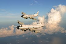
Busy? That's probably an understatement. When you run consecutive missions over a three or four day period with flights going out every 12 hours, it gets a bit hectic. While the flights can e dangerous and rough, some of the hardest work occurs during the 3 hour preparation for the flight. Preparations are orderly and proceed carefully using a well defined check list. After the aircraft is fueled with something like 7,500 gallons of jet fuel, the entire aircraft gets one last look over, a pre-flight safety briefing is held and engines are started to begin the flight process. The P-3s burn about 750 gallons of gas an hour, and with the price of aviation fuel being about $5.00 a gallon, you can see that the cost of a single 9 hour mission can be very expensive. That means you had better have everything working right, or you've spent a lot of money for not much return.


Although it seems like we've been at this for over a week, we are just starting our third day of flights with the P-3s. With Gustav moving along at a faster clip than originally forecast, it appears that tomorrow morning's 4:00 a.m. flight will be the last before landfall occurs.

While we continue to do profiles in support of our 3-dimensional horizontal wind fields derived from our tail doppler radar, we are also, on one of the P-3s, carrying out a very important mission to calibrate and validate surface wind measurements from the QuickScat satellite in regions of high winds and heavy precipitation. The collage shows in general how the process works. Ocean surface wind measurements obtained with this satellite have proven invaluable to forecasters in their efforts to more accurately describe actual surface conditions in hurricanes. This work has been going on for a number of years during both the hurricane season and in winter storm conditions in the North Atlantic or North Pacific.

I must say that we received a lot of support from the Cuban Government during the first couple of missions by allowing us to overfly Cuba to get to the storm while it was located in the Caribbean. This saved us a considerable amount of time and allowed us to obtain a more extensive data set.
Take a look at this Google representation of one of those flights.


1 comment:
Thanks Jim!
Post a Comment