

We've been asking ourselves this question. Is this the one? Many of us who have been around think not since this system is so close to the S. American coast and because there is a good bit of shear in the atmosphere - that means winds at high altitudes that rip the tops on the growing thunderstorms and inhibit any development. But, heck. We've been wrong before.
The two satellite images above were acquired today (click on them and use your back button to return to the blog). The one to the left is a visible picture which is what you would see if you were in the Space Shuttle hurtling around the earth. The second, to the right, is an IR (infrared) or thermal image which shows the cloud top temperatures - the more colorful, the colder and thus the higher the clouds. As you can see, most of the "convection" - rapidly growing cumulonimbus clouds - are just to the west of the apparent center of circulation. There really isn't much there, and that's one of the reasons many of us feel that this disturbance will not intensify into a tropical storm. But, as my wife says, I'm no forecaster.
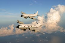
 Well, we are scheduled to deploy to St. Croix in the Virgin Islands (that's to the east and a little south of Puerto Rico) to start flying into whatever is there beginning Friday afternoon at 4:00 pm with the first of our two WP-3D Lockheed Orions, returning at about 2:00 am, with the second P-3 leaving a 4:00 am Saturday morning and returning at 2:00 pm Saturday afternoon. Crummy hours in my book, particularly since I have to see each aircraft off and meet it when it returns. We may repeat this sequence two or three times, and after bouncing around the sky for about 10 hours a day, three days in a row, the crew is pretty well done in. Even though we are on a lovely Caribbean island, there's not much enjoyment to be had.
The above shows the latest forecast track, taking the "storm" across the southern Caribbean. We'll see how this changes tomorrow morning and whether the storm is forecast to intensify. We'll have a final decision early in the morning as to whether we head SE to St. Croix or wait to fly another day.
That's enough for tonight. Still have to pack, and I have an early morning (3:30) get up - go ahead and shed a tear or two to see one of the aircraft off to Jacksonville for some minor maintenance that has to be done at the Naval Air Station there. If we go, I'll have much more to tell you in the coming days. For now, Good Night.

1 comment:
Nice job on the blog Dad.
I am apart of the safety committee at work, and we have our hurricane ride out teams and procedures. I am going to forward this along to the head of our EHS (Enviornmental Health and Safety) department. I know he has a guest speaker coming in to talk about hurricane season, but this will give him a more accurate feel of how the season is going. Who knows, you might have to come in and give a presentation on show and tell day.
Post a Comment