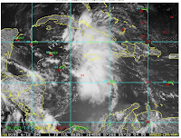
 A funny thing happened over the weekend - well, maybe not so funny. The easterly wave that I talked about in a previous Blog, shown to the right, was moving west but not showing signs of developing. Our research partners decided they wanted to study this wave to look at its characteristics and see if there was any hope for it to develop. Known as the Genesis Module, this experiment has multiple patterns that examine the storm at various stages of its life cycle. The first of these, which was the one planned for our first mission, is a zig-zag pattern at mid-
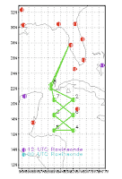 (about 14,000 ft.). When a circulation begins to develop in a wave, it normally does it at altitude and then works its way to the surface. Hence the value of such a pattern. The orientation is along the axis of the wave and its position is where the wave was forecast to be at the time of the flight.
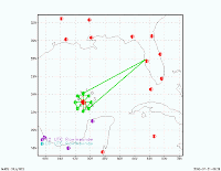
Well, Dolly continued to develop from that point, taking on the characteristic tropical storm look as shown to the left. We have continued to fly Dolly every 12 hours since Sunday, and as we approach the wee hours of Wednesday morning, the last of six consecutive flights is on the way back to our home base. The tracks into the storm have taken on a different look over the evolution of Dolly as shown to the left below. They are designed to acquire the best tail doppler radar set possible as explained in an earlier blog. Dolly finally strengthened to a weak Cat 1 storm this afternoon and does not appear to be getting much stronger. That's a blessing for those along the south coast of Texas and in Mexico. They'll get plenty of rain but not such high winds.
It's been an exhausting week for everyone, particularly because of the flight schedule. You are either on the 4:00 am or the 4:00 pm crew, and you start your day (night) at 1:00 am or 1:00 pm. Either way you travel from night into day or vice versa. After three, nine hour flights on this schedule the crew members are pretty well drained and, in some cases, down right testy. But, this too shall pass as we await the next storm where we will repeat the process. In the meantime, we have a few maintenance issues that we must deal with on the P-3s. They take a beating flying through those storms, and after three pounding flights into Dolly, they need some tender, loving care.
During the six flight P-3 evolution, our high-altitude jet, the G-IV, was also quite busy flying the dropsonde missions to obtain profile data to improve the track forecasts. It flew two
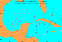
and one nighttime mission on Dolly, and as you can see by the figure here that the track of that aircraft covered a lot of area during its eight hours in the air. Each point on the track is the location of a dropsonde launch. This was the first flight in the sequence, and the subsequent two flights covered the Gulf of Mexico exclusively.
With the return of the last P-3 flight at 1:00 am this morning we are through with Dolly. As you recall from the previous blog, the disturbance that we had planned to fly from St. Croix and was written off as nothing more than a tropical wave finally encountered conditions that were favorable for its development into a hurricane. It appears that this time Mother Nature outsmarted the best forecasters. That's why we study these storms - to improve our ability to more accurately predict such events.
In case you missed Dolly's landfall into Texas, the image to the left is from the Brownsville National Weather Service radar. Nice looking storm.

Two pics of the aircraft involved in the Dolly missions - below is the Gulfstream G-IV preparing for one of its daytime missions with a P-3 in the background awaiting one of its evening missions. Above are the two P-3s together on the ramp at MacDill Air Force Base (our home), one having just returned and the other preparing for its evening flight.
The last picture in this posting shows the two pilots on the G-IV doing their pre-flight

before the mission.
Please click on any of these images to see an enlarged version of them. Hit the back button of your browser to return to the blog.
AL97 sits near the Cape Verde Islands, but at this time the models indicate that it will be turning north into the central Atlantic in the next few days and not be a factor for the Islands or the U.S. As this is the case, the author of this blog is taking a week off and heading for Wisconsin to a small town on the bay north of Green Bay. I'll resume this blog when action in the Atlantic picks up once again.


No comments:
Post a Comment